메뉴 건너뛰기

자유게시판

Memorial Day 연휴 Camping 안내

2009.05.07 10:18

John 조회 수:1440

Grand Canyon Collage-2.jpg


Memorial Day (5/23.24,25)
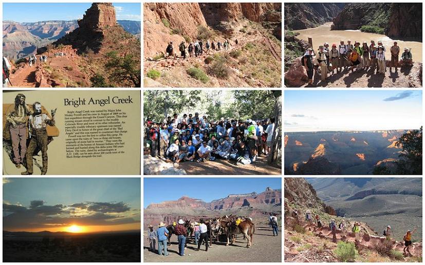

1. 가는곳:: 그랜드 캐년

2. 캠프싸이트 Group Camp Site

3 캠핑날짜 : (5/23,24,25)

4. 교통편 : 대형 뻐스(50인승)

5. 집합장소 및시간: 5월 23일
                  LA:    6 AM (한남체인)
                 동부:  7 AM (그린마켓)


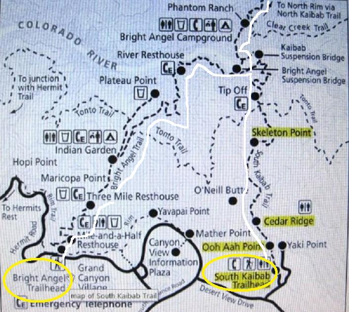
6. Trail : A 팀: South to South( South Kaibab Trail  to Bright Angel Trail,).15.8마일. 
              B 팀: Arizona's Highest  Humphreys Peak ( 12,642 feet) 등반.
              C 팀: Bright Angel to Indian Garden  Trail 4.6 마일(편도)
7. 회비 : $150.(교통비,캠핑사이트,출발당일 아침,저녁 갈비파티)

8.준비물; 개인 캠핑장비및 음식(팀 별로),식기.및 개인 간식

 * 무전기, *헤드램프,*선불락 로션, *선그라스, *챙이긴 모자,*긴필상의,*긴바지,*비상식량, *트랙킹폴, *물(16온스 5병 Trail중)
 * 각자 필수입니다.

9. 준비위원:
                  배대관 909-641-9106
                 정금숙 909-624-3694
                 송정순 323-222-3000
                 문의사항은 준비위원께 문의 바람.

10. 기타 : South Rim 에서 North Rim 으로...
                  교통편 제공하실 Volunteer 연락바랍니다.

***  安 全 한 산행을 위해 철저한 준비을 하여 주십시요.
*** 산행중에 발생하는 모든사고는 각자의 책임 임으로 본 산악회는 어떠한 책임도 없음니다.


  Sunrise/ Sunset Times and Moon Phases

Where Are the Best Views ?

There is no one best place for watching sunrise or sunset, just good places and better places. Download Grand Canyon Sunrise/ Sunset (103kb PDF File) for insider information. 


Date

Sunrise

Sunset

     
Mar. 01 6:58 a.m. 6:24 p.m.
Mar. 10 6:46 a.m. 6:32 p.m.
Mar 20 6:32 a.m. 6:41 p.m.
     
April 01 6:14 a.m. 6:51 p.m.
April 10 6:02 a.m. 6:58 p.m.
April 20 5:49 a.m. 7:07 p.m.
     
May 01 5:36 a.m. 7:16 p.m.
May 10 5:27 a.m. 7:24 p.m.
May 20 5:19 a.m. 7:32 p.m.
 
New Moon Full Moon Moon Rise
     
  Feb 09 6:33 p.m.
Feb. 24    
  Mar. 10 6:29 p.m.
Mar. 26    
  April 09 7:29 p.m.
April 24    
  May 08 7:24 p.m.
May 24    


5월 24일 해뜨는 시긴은 5시14분이 되겠읍니다.
그 장관이 대단 합니다.


Grand Canyon National Park
Backcountry Trail Distances

Corridor Trails Distances

South Kaibab Trail: The trail begins on the South Rim near Yaki Point, and descends to the Colorado River. Elevation change from rim to river is 4860 ft (1480 m), along a 6.3 mile (10.1 km) trail. Because of the unavailability of water and steepness of this trail, rangers recommend hiking down this trail only - and recommend using the Bright Angel trail for the hike out on the next day.

River Trail: The trail has little elevation variation and follows the Colorado River for 1.7 miles (2.7 km) between the Bright Angel and South Kaibab trails. Two foot bridges permit access to the north side of the Colorado River.

Bright Angel Trail: The trail begins on the South Rim just west of Kolb Studio, and descends to the Colorado River. Elevation change from rim to river is 4460 ft (1360 m), along a 7.8 mile (12.6 km) trail.

North Kaibab Trail: The trail begins on the North Rim at the head of Roaring Springs Canyon and descends to the Colorado River. Elevation from rim to river is 5850 ft (1780 m), along a 14.2 mi (22.9 km) trail.

DW - drinking water
TF - Toilet Facilities
EP - Emergency Phone
RS - Ranger Station
CG - Campgrounds

Distance Via: Distance from Rim (mi/km) Elevation (ft/m) DW TF EP RS CG Other
Bright Angel Trailhead to:   6860/2091            
1.5 mile Resthouse 1.5/2.4 5720/1743
Y
 
Y
 
Y
 
-
 
-
 
water available May-Sept only
3 mile Resthouse 3.0/4.8 4920/1450
Y
 
-
 
Y
 
-
 
-
 
water available May-Sept only
Indian Garden 4.6/7.4 3800/1158
Y
 
Y
 
Y
 
Y
 
Y
 
picnic tables
Plateau Point 6.1/9.9 3740/1140
-
 
-
 
-
 
-
 
-
 
 
River Trail Junction 7.7/12.5 2446/746
-
 
-
 
Y
 
-
 
-
 
 
Bright Angel Campground 9.3/14.9 2480/756
Y
 
Y
 
Y
 
Y
 
Y
 
picnic tables
Phantom Ranch 9.6/15.4 2546/776
Y
 
Y
 
Y
 
-
 
-
 
reservation required for food and lodging; pay phone
South Kaibab Trailhead to:   7260/2213            
Cedar Ridge 1.5/2.4 6320/1926
-
 
Y
 
-
 
-
 
-
 
 
Tonto Trail Junction 4.4/7.1 4000/1219
-
 
Y
 
Y
 
-
 
-
 
distance to Indian Garden via Tonto Trail - 4.6 mi/6.6 km
River Trail Junction 6.0/9.7 2640/805
-
 
-
 
-
 
-
 
-
 
 
Bright Angel Campround 6.8/10.9 2480/756
Y
 
Y
 
Y
 
Y
 
Y
 
picnic tables
Phantom Ranch 7.2/11.6 2546/776
Y
 
Y
 
Y
 
-
 
-
 
reservation required for food and lodging; pay phone
North Kaibab Trailhead to:   8250/2515            
Supai Tunnel 2.0/3.2 6800/2073
-
 
Y
 
-
 
-
 
-
 
occasional seasonal water
Roaring Springs 4.7/7.6 5200/1585
Y
 
-
 
-
 
-
 
-
 
water available May-Sept. only
Cottonwood Campground 6.8/10.9 4080/1244
Y
 
Y
 
Y
 
Y
 
Y
 
water available May-Sept. only. picnic tables
Ribbon Falls 8.3/13.4 3720/1134
-
 
-
 
-
 
-
 
-
 
waterfalls, day use only
Phantom Ranch 13.7/22.0 2546/776
Y
 
Y
 
Y
 
-
 
-
 
reservation required for food and lodging; pay phone
Bright Angel Campground 14.1/22.7 2480/756
Y
 
Y
 
Y
 
Y
 
Y
 
picnic tables
River Trail Junction 14.2/22.9 2400/732
-
 
-
 
-
 
-
 
-


Tonto Trail Distances

Tonto Trail: This trail crosses the Tonto Platform approximately 3900 ft (1200 m) below the South Rim, intersecting both the Bright Angel and South Kaibab Trails.

For a table showing distances along the Tonto Trail view the following PDF file: Tonto Trail Distances.

위로